Foinikas Revisited
When we first blogged about Foinikas it was springtime, and the abandoned village was bathed in a sea of yellow. It was always an essential destination on our holidays, but we had never been in Spring, so it came as a pleasant surprise. However, it made it difficult to explore, as you never know what you might tread on when you have to wade through thigh-high flowers. As frequently happens with our blogs, people posted more information about the site in the comments. Of particular interest was the age of Foinikas. Apparently, it used to be the regional head quarters for the Nights Templar, when they ruled the island. So we decided to pay another visit a few days ago, and explore it in more depth...
Let's Start Near Nata

If you remember Max's blog on Sinti Monastery, you will know where this is. It is the new bridge than crosses the Xeros River. You need to approach it from Nata, and turn right just before it.
NB: please remember that while this blog is a record of a journey we took, you will be taking your own journey, and you will be responsible for your own actions. So if you drive into the river by mistake, it is down to you. If you are at all unsure about any aspect of any trip, just don't do it! Get out of the car and check the route ahead. If it looks uncomfortable, just back off.

Take The Low Road

Cypriots drive to Foinikas in a variety of cars, as the banks of the reservoir provide good fishing opportunities. We always use a 4x4, but at the moment the track is in fairly good nick.
Keep Near To The Cliff

Stay on the main track and you will never stray far from the riverbed. There are numerous tracks going off to your right and left. Most of these will just rejoin the main track later on.
In Spring This Had Lots of Water

After lots of rainfall the Nata Route can get blocked off. In spring this was a raging torrent, though in most summers it is like this.
An Odd Wall

This looks like an odd picture to include in the blog. However, there is a good reason for this. On the other side of the wall is a gravel slope. We once approached the river from that side, and were going to drive up the rather steep incline until a little voice told me to check the route first. It would have been a bit of a disaster if I had driven off it.
Page 1 of 13

Related Blogs:

Foinikas Views
We just can't keep away from Foinikas. Somebody posted some pics of the abandoned village on our Paphos Chat facebook group, and people were asking how to get there. We bumped an old blog showing the route, but decided that a film was also needed. While we were out shooting it, we decided to take some more shots, but this time we went for some outstanding views...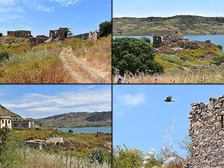
Foinikas by the Lake
The abandoned village of Foinikas lies on the banks of the Asprokremmos Reservoir. Now that the waters are lapping at the village boundaries, we thought we would pay it another visit, to see how it looks now.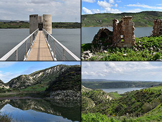
Foinikas Is Cut Off!
While Paphos waits for the Asprokremmos Dam to overflow, we thought we might as well photograph the rest of the reservoir, which is to all intents and purposes, now full. So we set off to Foinikas looking for some beautiful landscape nature shots. We didn't get very far though...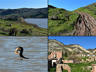
Who is Vandalising Foinikas?
The Asprokremmos is filling up fast, so we decided to see if we could still drive to Foinikas, the abandoned historical village which lies on its banks. We succeeded, and took some lovely photographs, but also had a nasty surprise...
Abandoned Villages - Kato Archimandrita
A few weeks ago we visited the sleepy hamlet of Archimandrita. We touched briefly then, on its abandoned neighbour, but got distracted with other things before we were able to visit it and tell you what we found. Better late than never, here is our look at Kato Archimandrita, a village abandoned due to its remoteness and ruled now by goats.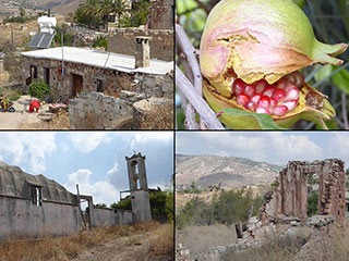
Old Choletria
Modern Choletria lies on the F617. You might drive through it if you are headed up to the Troodos from Paphos. However, if you are approaching from the direction of Nata, you will first arrive at Old Choletria. At first glance, there is not much to see here, but it is worth taking a slight detour to explore...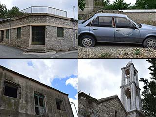
Abandoned Villages - Statos
Statos is unusual, as abandoned villages go. People deserted it not because of inter-communal fighting, but because of the threat of landslides. And then, no sooner had they emptied, some of the abandoned buildings were repopulated. Were villagers returning, or had outsiders moved in, prepared to take the risk of landslide?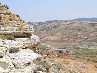
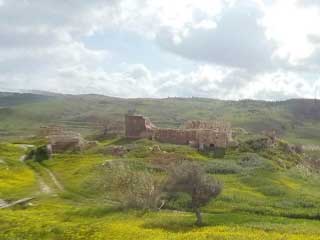
Foinikas Heights
We love Foinikas, the abandoned village on the banks of the Asprokremmos Reservoir. We've already blogged about it twice though, so we thought we would take a look at some of the surrounding countryside, and see what else the valley has to offer. Hopefully we will show you that you can find stunning, remote scenery only a stones-throw from Paphos. You don't need to travel all the way to the Akamas or Troodos to lose yourself in rugged beauty...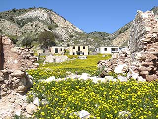
Abandoned Villages - Foinikas
Foinikas has a special place in our family's hearts. It was the first abandoned village we explored in Cyprus, some ten years ago. We have returned to it each time we visited Cyprus, and consquently have more pictures than we could ever possibly want of the village and surrounding area. We posted some of them on our blog about the Asprokremmos Reservoir. We wanted some up-to-date photos for the Abandoned Village blog series. So last saturday we revisited Foinikas, and couldn't believe what we found when we got there...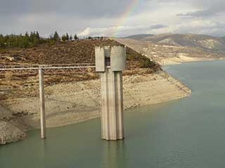
Should We Be Worried About Our Water?
Over the last few years, the water level in the Asprokremmos has gotten lower and lower. Should we be alarmed? Has it been this low before?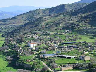
Abandoned Villages - Souskiou
It's time to return once more to the Diarizos Valley, which lies on the border of Paphos and Limassol. Before Easter we had been exploring the abandoned villages and sleepy hamlets, and I want to show some more of the pictures we took, before the approaching summer heat makes them unrecognisable. So on this blog we shall visit Souskiou. Easy to miss as you drive up the valley, it is nevertheless one of the largest abandoned villages you will likely meet on your travels in Cyprus.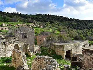
Abandoned Villages - Maronas
Last saturday my wife and I were in Paphos with a couple of hours to kill. So we decided to take a trip up the Diarizos Valley. Being on the Paphos / Limassol border, this valley is on the edge of the Paphos Life radar. However, it has a wealth of sites to visit, as you shall see over the coming weeks. Our specific destination was the abandoned village of Gerovasa. There is a fascinating bridge near to it, and we visited the village itself a few years ago, to do a geocache. However, on our way up the valley, we spotted some ramshackle buildings on the other side of the valley, and decided to take a detour...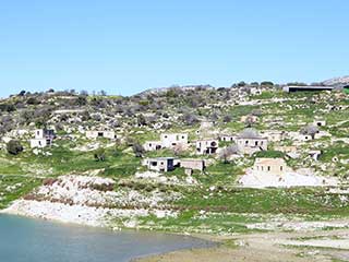
Abandoned Villages - Evretou
Evretou is just off the B7 near Polis. It lies on the banks of the Evretou Reservoir, and is another sad testament to the troubles of 1974.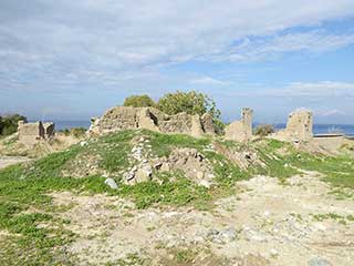
Abandoned Villages - Makounta
We recently assisted on a litter cleanup along the nature trail to Argaka Reservoir. While we were there, we couldn't help but notice the abandoned village of Makounta on the other side of the valley. We were also curious where the nature trail went once it passed the reservoir. So the other day we returned with our camera. This is what we found...Related Pages

Video ClipDriving Off Road Through Foinikas
A quick clip of a drive through the abandoned village of Foinikas near Paphos, in the spring of 2018. The area is about to become a sea of yellow.
360 PanoramaFoinikas Virtual Tour
Join us as we take a virtual tour of Foinikas in springtime. We originally produced this for an Easter Egg competion.
Good Pages To Visit

FB PagePaphos Life on Facebook
Like us on Facebook and stay notified of new blog posts.

FB PageOur Facebook Chat Group
Paphos Chat has been created for people who like our site and want to chat using Facebook. You can also easily upload photos of any size here. A lot of people are members of the Facebook chat group and the main forum. It's entirely up to you.

ListBlog Locations
Planning a day out? Then use our map of blog locations as a handy guide. Some of the places we visit our closer to each other than you might think, so take a look and start planning your next adventure...

eBookCyprus Road Trip 01: the Kathikas - Panagia Loop
Let me take you on a journey around the region of Paphos, Cyprus. Starting at Paphos itself, we travel to Akoursos, then Kathikas, Kritou Terra and Simou. We continue past Lasa and Kannaviou, before taking in the delights of Panagia. Getting a bit more adventurous, we visit the abandoned villages of Statos and Agios Fotios, before passing through Choulou, Letymbou and Polemi, and rejoining the main Paphos - Polis road.
The route is suitable for all types of vehicle, and requires no off-roading. The guide contains about 130 photographs including shots of all the road signs you need to pay attention to, as well as some of the highlights you may experience along the way.
There are also several maps which will help you keep your bearings.
You can do this journey in a day, or you can break it up into chunks. You can also do it in reverse, to get some completely different views. It is entirely up to you.


