Moundiko Nature Trail - Part 1
Picnic Spot

Soon you will come across this picnic bench. As well as another sign, there is also a handy map.

A Better Map

This is a good map, as it is fairly accurate when it comes to describing the circular part of the walk. You are currently standing at the Point of View.
A Worse Map

If you look at this map, the route is a mirror image of the previous map. This is very confusing. The problem arises because the maps can appear on either side of the trail. However, the people who placed the signs wanted them to have the Kathikas end in the direction of Kathikas. Now, if you used the same map image in two signs, but they were on opposite side of the track, then one of the maps will be facing in the wrong direction. So what the sign maker has done is rotate the map 180 degrees. Unfortunately, this means that if you follow the map you are likely to take the wrong turn when you reach the circular path. If you look, just after Point 7, they want you to turn left to get to point 9. You actually need to turn right.
What they should have done, instead of rotating the image 180 degrees, is flip it horizontally.
You may wonder why I am labouring this point. It is because I made lots of wrong turns in the second part of this article because I paid too much attention to this sign.
Moundiko Plateau and Snake Canyon

Anyway, what did the sign say?
The southern gorge to the left is called "Farkonias". The name derives from the English word Falcon.
The first plateau to the left of the Farkonias gorge is called "Moundiko", toponym from which this route took its name.
[a toponym is a place name, especially one derived from a topographical feature]
The gorge to the right of Moundiko is called "Koufon" and "Erini". The word koufes refers to snakes, while the word Erini refers to a woman's name called Eirini.
The plateau to the right of the Koufon / Erini Gorge is called "Lipati". Further to the right of Lipati is the "Dipotamos" gorge.
I first wrote about the gorge to the right of Moundiko a few years ago. I even did a film about driving to "Snake Canyon." I called it that because every time I walked down it (twice) I almost stood on an Adder. I didn't know what it was called so named it Snake Canyon. So I was delighted when I read this sign and found out that that was its actual name! This is worth remembering should you ever want to venture down there. Wear decent boots.
Sign Number 4

In this part of the walk, the information signs are coming thick and fast. This is the next one:
The view from here is panoramic.
The rock on the one side of the route is chalk and maris of the Pachna Formation. This consists almost entirely of small fossils of shells of marine microorganisms. The rock was created at the bottom of the sea when the sediment was still incoherent. Organisms like worms dug it, creating galleries in the soft material. With its solidification, their traes remained on the rock as trace fossils. The rocks of the area consist mainly of chalks and maris of the Pachna Formation, about 20 million years old, which lie in the incoherent clay rocks of the Kathikas melange 60 million years old and longer. Before the Moundiko plateau, we observe a geological window, where the underlying clay rocks are revealed due to the erosion of the overlying chalks (smooth topography and low vegetaion), whle they are surrounded by overlying younger limestone Pachna rocks with steeper topography (fertile soils and taller vegetation). The area is prone to landslides due to the presence of clays, Due to overgrazing in the area, deforestation and soil erosion are observed in several places. After a short downhill course, the route raches a junction where its circular part begins towards the Moundiko plateau.
I had to look it up but "incoherent sediment" is defined as "textures consisting of loose sediments which have never been cemented."
Page 2 of 10


Related Blogs:
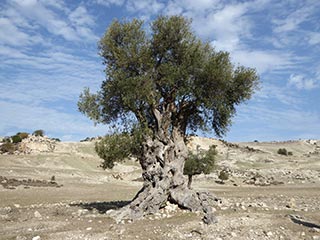
Is this the Oldest Olive Tree in Cyprus?
We were out exploring in the Akamas the other day, and we came across this lovely old Olive Tree. I can't help wondering how long it has stood here...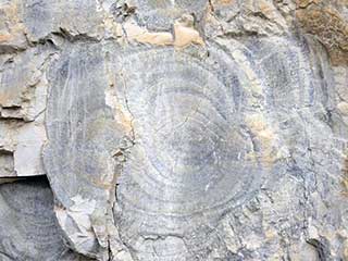
Liesegang Rings in the Akamas
As 2016 draws to a close we decided to take a final trip to the Akamas. We have been trying to locate some interesting fossils we saw a few years ago, and the last couple of times we had tried we had ended up somewhere else. We found the right route this time though.
Akamas Narcissus
The Akamas is home to an abundance of wildflowers, from orchids to wild tulips. Near Arodes, there is a certain field set aside for a small yet very beautiful flower. Come and say hello to the Akamas Narcissus.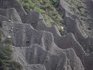
Erosion
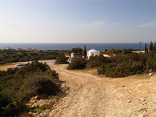
A few weeks ago, I read reports that some ancient human remains had turned up in a remote church near Kathikas. I presume the remains were placed by a tomb robber, but to be honest, the key phrase that stuck in my head was "remote church". After several attempts, the route to the location was found, and we paid it a visit.Related Pages
Video ClipAkamas Heights to Agios Georgios
In this film we drive down from the Akamas to the right of White River Gorge. This is the gorge that forms a physical boundary between the Akamas and Peyia. We take an off-road track down to a lovely church, before descending to White River Beach itself. We then follow the road down to Agios Georgios, finishing at the harbour.
Good Pages To Visit

FB PagePaphos Life on Facebook
Like us on Facebook and stay notified of new blog posts.

FB PageOur Facebook Chat Group
Paphos Chat has been created for people who like our site and want to chat using Facebook. You can also easily upload photos of any size here. A lot of people are members of the Facebook chat group and the main forum. It's entirely up to you.

ListBlog Locations
Planning a day out? Then use our map of blog locations as a handy guide. Some of the places we visit our closer to each other than you might think, so take a look and start planning your next adventure...

eBookCyprus Road Trip 01: the Kathikas - Panagia Loop
Let me take you on a journey around the region of Paphos, Cyprus. Starting at Paphos itself, we travel to Akoursos, then Kathikas, Kritou Terra and Simou. We continue past Lasa and Kannaviou, before taking in the delights of Panagia. Getting a bit more adventurous, we visit the abandoned villages of Statos and Agios Fotios, before passing through Choulou, Letymbou and Polemi, and rejoining the main Paphos - Polis road.
The route is suitable for all types of vehicle, and requires no off-roading. The guide contains about 130 photographs including shots of all the road signs you need to pay attention to, as well as some of the highlights you may experience along the way.
There are also several maps which will help you keep your bearings.
You can do this journey in a day, or you can break it up into chunks. You can also do it in reverse, to get some completely different views. It is entirely up to you.


