Pano Akourdaleia Nature Trail
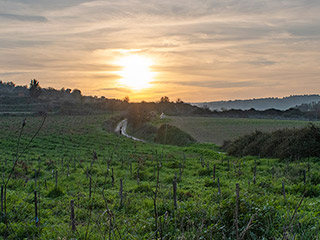
End Of The Line

I battled my way along the path until I arrived at the stream. Clearly this was the end of the trail.
View From Above

You can see where the path ended from this drone shot. So that was that. I had enjoyed my walk along the nature trail, and thought that it was a shame it was a bit neglected. I returned up the trail to my car and started to head for home. I was curious where the gorge might end up though, so I took a right turn off the main Kathikas road. This brought me to the cave church I wrote about a couple of months ago. Indeed, it was writing that article that first alerted me to the gorge. So it was nice to have a bit of closure to my adventure.
However, as I was passing the church, I noticed a familiar looking sign to the right, which I had missed on my first visit...
Panagia Chrysophilotissa Church

The text referred only to the church itself.
It concerns a contemporary country church, dedicated to Virgin Mary (Panagia). It is believed that Virgin Mary heals eye problems and the local people scrape the sooty catacomb walls and smudge their eyelids to cure the disease. Next to the church as well as at other places in the vicinity there are ancient catacombs with frescoes. Alsom during the Middle Ages there was a settlement in the area with the name Thermokrini, which is often mentioned in old texts and maps. The settlement was destroyed by the end of the Ottoman period, however scatted foundations and ruins can be seen. Several legends and stories are connected with the settlement such as the story of "Christinou tis Themokrinis", a girl who preferred to suicide rather than to be disgraced by the Ottomans. A traditional song is still passing from generation to generation, descibing the story of Christinou.
A Familiar Map

As well as the information on the church, the sign also had a rather familiar map. I originally assumed it was for another trail, but it was only when I checked my photos later that I realised that it was the same map as the Pano Akourdaleia Nature Trail. But that could only mean that it actually finished here, by the church. So the stream I found was not the end.
Incidentally, I googled "Christinou tis Themokrinis" and got only one result. It was part of a geocache description:
This area was an important medieval settlement, known as Thermokrini. It disappeared at the end of ottoman occupation. The church is dedicated to a beautiful young girl from Thermokrini village, Christinou tis Themokrinis. The priests daughter she was desired by the ottomans for her beauty, and they wished to give her to there sultan. Rather than dishonour her family and village she killed herself. A traditional song is still sung locally about Christinou.
Where is the Trail?

Anyway, I decided to have a quick look to see if I could pick up the nature trail from this end. If you go to the car park next to the church you will see a trail heading down the valley.
Page 7 of 15


Related Blogs:
Agios Efraim Walk
The Ezousa River carves a path through the Paphos countryside from Kannaviou down to Acheleia, entering the sea by Paphos Airport. In its wake it leaves some beautiful countryside and a wide variety of flora and fauna. This little walk takes you through some of the hills and fields surrounding the upper reaches of the Ezousa, near the village of Lemona. There are even some ruins for you to explore.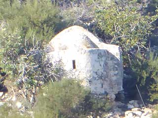
If You Go Down To The Woods Today...
If you have ever driven to the Blue Lagoon via the coastal road, you can be forgiven for not spotting this delightful little church en route.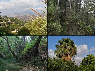
The Anerades Nature Trail
Continuing our look around the countryside near Miliou, we are going on a walk up this gorgeous nature trail. You have three options on this route. On this occasion we take the blue pill, so join us as we ascend a lovely gorge...
Arnies Nature Trail
Yesterday, for the first time since March, we drove somewhere in order to have a walk. It was magnificant! We didn't drive far, just down the road. There is a nature trail which we walked before Christmas, and we thought it was the perfect place to start reacquainting ourselves with the Cyprus countryside.Related Pages

MapPano Akourdaleia Nature Trail
This year I've spend a fair bit of time exploring the countryside around Akourdaleia. It fascinates me, partly because of its staggering beauty, and partly because it is unknown to most people. A huge gorge runs between it and Kritou Tera, yet it is invisible from any of the main roads. While investigating this gorge, I came across a Nature Trail I hadn't heard of before. So come with me as I explore it.
Good Pages To Visit

FB PagePaphos Life on Facebook
Like us on Facebook and stay notified of new blog posts.

FB PageOur Facebook Chat Group
Paphos Chat has been created for people who like our site and want to chat using Facebook. You can also easily upload photos of any size here. A lot of people are members of the Facebook chat group and the main forum. It's entirely up to you.

ListBlog Locations
Planning a day out? Then use our map of blog locations as a handy guide. Some of the places we visit our closer to each other than you might think, so take a look and start planning your next adventure...

eBookCyprus Road Trip 01: the Kathikas - Panagia Loop
Let me take you on a journey around the region of Paphos, Cyprus. Starting at Paphos itself, we travel to Akoursos, then Kathikas, Kritou Terra and Simou. We continue past Lasa and Kannaviou, before taking in the delights of Panagia. Getting a bit more adventurous, we visit the abandoned villages of Statos and Agios Fotios, before passing through Choulou, Letymbou and Polemi, and rejoining the main Paphos - Polis road.
The route is suitable for all types of vehicle, and requires no off-roading. The guide contains about 130 photographs including shots of all the road signs you need to pay attention to, as well as some of the highlights you may experience along the way.
There are also several maps which will help you keep your bearings.
You can do this journey in a day, or you can break it up into chunks. You can also do it in reverse, to get some completely different views. It is entirely up to you.


