Finding Prodromos Monastery
In the final part of our series on the area around Martiri Bridge, we investigate why it was built, and in doing so learn about a nearby abandoned monastery. We also take the drone for a spin, to get some more spectacular views of the surrounding countryside...
Above The Bridge

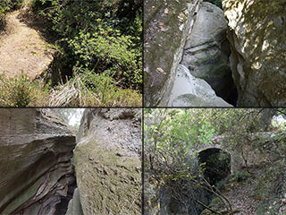
We shall begin our adventure on the road above Martiri Bridge, which we already blogged about, along with the spectacular gorge below it. Since publishing those articles, we are delighted to see that some people have explored the area themselves after reading our words. So this view will be familiar to at least a few of you. Here we are heading down to the bridge from Koili.

An Interesting Map

Now, once we had found the bridge, the question naturally popped up, why was it built? To find a possible answer, we turned to the National Library of Scotland. They have an online historical map viewer. It even has a side-by-side more, where you can compare the old map with a current one. In the picture above, I am comparing a Kitchener Map from the 1900s with a modern satellite image. It is plain to see that there were the ruins of something called Prodromos pretty much exactly where a path from the bridge would lead to. If you look on right hand image, you can see a faint zig-zag track about two centimetres to the right of the tip of the arrow. That is the track that leads down to the bridge.
So the next question is: What was Prodromos?
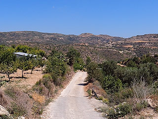
Distant Prodromos?

This view shows the route the path takes.
A quick bit of research (google) revealed only the following, with reference to Prodromos and Koili:
"There are also two ruined monasteries, Agios Georgios and Timios Prodromos."
We visited Agios Georgios a couple of months ago. Coincidentally, we found that when we were out looking for Martiri Bridge. It was reasonable to presume that the ruins of Prodromos referred to Prodromos Monastery. So we can assume the bridge was built for them.
Drone Scout

We took our drone with us for some of the visits to the area. It is very useful for scouting out the valley. This is the view downstream. At the bottom, we can see the path winding its way around the hill, but there are no sign of any ruins.
Drone Film
Here is some of the footage we shot. It contains spoilers as to the location of the monastery, so if you don't want to interrupt the blog narrative you can watch it later. I put it on the first page though, so that the casual viewer not yet engaged enough to read the whole six pages of this epic adventure, might see what's in store and have their curiousity piqued.
Page 1 of 6

Related Blogs:
Martiri Bridge
We've spent the last few years bringing you reports from all corners of Paphos and Cyprus. The next three blogs are about a fantastic area that is barely known, yet right on our doorstep. In the first part, we take you to see Martiri Bridge, which lies hidden in the countryside near Koili.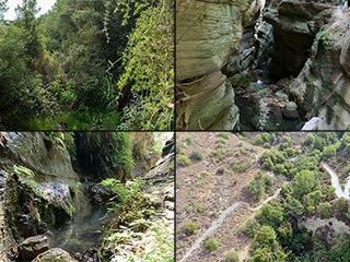
Martiri Gorge
A few days ago we introduced you to Martiri Bridge. That was pretty impressive, but in truth it was merely a starter. To experience the main course, you need to go below the ancient stone structure, and visit the gorge that runs beneath it...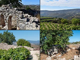
Ayios Georgios Monastery, Near Koili
Koili is a little village nestled on top of the hills above Paphos. It is surrounded by beautiful countryside which we love to explore. While researching the area we stumbled upon these ruins of an old monastery.
Topographical Maps Of Cyprus - Review
Recently we saw an advert for a new book of Cyprus Maps on Facebook, which perked our interest. We contacted the publisher and they kindly sent us a review copy. We've spent a few weeks scrutinising it, and here are our findings.Related Pages
Video ClipFrom Koili to Martiri Bridge
Good Pages To Visit

FB PagePaphos Life on Facebook
Like us on Facebook and stay notified of new blog posts.

FB PageOur Facebook Chat Group
Paphos Chat has been created for people who like our site and want to chat using Facebook. You can also easily upload photos of any size here. A lot of people are members of the Facebook chat group and the main forum. It's entirely up to you.

ListBlog Locations
Planning a day out? Then use our map of blog locations as a handy guide. Some of the places we visit our closer to each other than you might think, so take a look and start planning your next adventure...

eBookCyprus Road Trip 01: the Kathikas - Panagia Loop
Let me take you on a journey around the region of Paphos, Cyprus. Starting at Paphos itself, we travel to Akoursos, then Kathikas, Kritou Terra and Simou. We continue past Lasa and Kannaviou, before taking in the delights of Panagia. Getting a bit more adventurous, we visit the abandoned villages of Statos and Agios Fotios, before passing through Choulou, Letymbou and Polemi, and rejoining the main Paphos - Polis road.
The route is suitable for all types of vehicle, and requires no off-roading. The guide contains about 130 photographs including shots of all the road signs you need to pay attention to, as well as some of the highlights you may experience along the way.
There are also several maps which will help you keep your bearings.
You can do this journey in a day, or you can break it up into chunks. You can also do it in reverse, to get some completely different views. It is entirely up to you.


