From Kannaviou To Polis Off Road
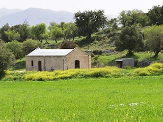
A Distant Sarama

In the distance, we can see Sarama. You can also get to Sarama from Skarfos Bridge, so if you are constructing your own trip, you can link this one with a trip to there and Simou, if you fancy.

A Sarama House

This is what Wikipedia has to say about Sarama:
___
Sarama is a deserted Turkish Cypriot village in the Paphos District of Cyprus, located 7 km south of Lysos. The village was devastated by an earthquake, which appears to be the reason it was deserted, although an insect destructive to the corn crop was reported to be affecting farmers of the village in 1879. Thermal springs in the vicinity indicate powerful hydrothermal activity.
___
There is now a fairly substantial farm at Sarama, which is certainly not abandoned.
Water Feature from 1957

This old water feature is interesting, because of the date stamp. It was speculated that these water features which can be found throughout the Paphos region, were constructed to commemorate the UK Queen's coronation, as most of them have a date stamp of 1952. However, we have also seen some stamped 1951 and 1954, though older ones tend to have the WSID prefix, which basically stood for the Cyprus Water Board. So this stamp of ER 1957 effectively kicks the coronation theory to touch. It is more likely to just be a coincidence.
Take The Road to Istinjo

If you want to follow our route, take the road to Istinjo. You will get to this sign by sticking to the right side of the farm. If you go straight through the middle of the farm you are more likely to end up in Lysos.
The Route Travelled So Far

A last look back to the forest, for now...
Interestingly, when we descended from the firebreaks, we did so on a different track to what we expected. If I didn't know better, I would swear that we were driving down a rally track. This could also explain how on a previous visit to the area we had driven past a couple of guys in a souped up hatchback, who asked us for directions. Do they hold rallies in the are a here at all, or am I letting my imagination run away with me?
Page 4 of 7

Related Blogs:
Agios Charalambos
Let's take a little break from flowers. I know that Cyprus looks lovely in the Spring, and that it abounds with colour and life. But it' time to take a break. With the Polemi Tulip Festival fast approaching, and the knowledge that another road trip from Max is just around the corner too, I think we need to look at something without petals.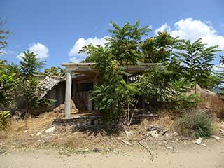
Abandoned Villages - Istinjo
Istinjo is an abandoned little village, with an active farm, just east of Filousa. You won't find it on Google or Bing Maps, unless you opt for satellite view and locate it manually. We have driven past it on numerous times ourselves before we realised it was actually an old village; from the main road it looked more like a slightly ramshackle farm. We only found out it's name when we did our Polis route the other other day. However, on that occasion we decided to stop and have a bit of an explore. Given that we had been following roadsigns to Istinjo since Sarama, it only seemed fair. This is what we found...
Roudia Bridge
Now that we have covered the route from Vretsia to Kelefos, let's return to the subject of Venetian Bridges. This time, we will feature Roudia Bridge. For years this eluded us, as we drove past it without realising it was there. With the help of the previous blog, you should now be able to locate it and know where to park the car. So let's take a look at the bridge itself...
Abandoned Villages - Melandra
We first stumbled upon Melandra last Autumn. We were trying to find an interesting route from Pano Panagia to Polis, and having visited a number of isolated villages, decided to venture off-road. The countryside at the time was very brown and arid. So when we revisited the village this May, we hardly recognised the place.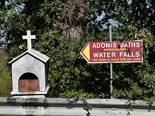
The Drive To Adonis Baths
Yesterday we posted a film showing the drive to Adonis Baths. It provoked a lot of comment, so here is the accompanying blog which will hopefully answer any questions.Good Pages To Visit

FB PagePaphos Life on Facebook
Like us on Facebook and stay notified of new blog posts.

FB PageOur Facebook Chat Group
Paphos Chat has been created for people who like our site and want to chat using Facebook. You can also easily upload photos of any size here. A lot of people are members of the Facebook chat group and the main forum. It's entirely up to you.

ListBlog Locations
Planning a day out? Then use our map of blog locations as a handy guide. Some of the places we visit our closer to each other than you might think, so take a look and start planning your next adventure...

eBookCyprus Road Trip 01: the Kathikas - Panagia Loop
Let me take you on a journey around the region of Paphos, Cyprus. Starting at Paphos itself, we travel to Akoursos, then Kathikas, Kritou Terra and Simou. We continue past Lasa and Kannaviou, before taking in the delights of Panagia. Getting a bit more adventurous, we visit the abandoned villages of Statos and Agios Fotios, before passing through Choulou, Letymbou and Polemi, and rejoining the main Paphos - Polis road.
The route is suitable for all types of vehicle, and requires no off-roading. The guide contains about 130 photographs including shots of all the road signs you need to pay attention to, as well as some of the highlights you may experience along the way.
There are also several maps which will help you keep your bearings.
You can do this journey in a day, or you can break it up into chunks. You can also do it in reverse, to get some completely different views. It is entirely up to you.


