Fasoula
Fasoula is nestled in the Diarizos Valley, between the abandoned villages of Souskiou and Maronas. We visited it in the Spring time, but have saved the blog for now, so you can remember how green Cyprus was just a few months ago, as you sit by the pool relaxing in the summer heat...
How Green Is My Valley?

If you only ever visit Cyprus in the summer you will be amazed to see what it looks like in Spring. Here is Fasoula, nestled in the Diarizos Valley. We are viewing it from above. There is a very good shortcut here from the F617, but that's for another blog.
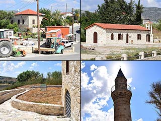
From here, you can see the Church. What you can't see is the mosque. That's because it is hiding behind the trees. So let's go down and take a look.

Distant Souskiou

As you descend to Fasoula, you can see where Souskiou is, in the distance, on the other side of the valley.
The Main Drag

Fasoula is only a small village. It used to be populated by Turkish Cypriots, but they left after the troubles. In their place came Greek Cypriots who were displaced from the North.
This is what the PRIO database has to say about Fasoula:
Fasoula is a village located in Dhiarizos valley, twenty kilometers east of Paphos (Ktima) and three kilometers southwest of Mamonia. Goodwin suggests that although Fasoula means “beans” in Greek and Turkish, however, the village was most probably named after an early land owner. In 1958 Turkish Cypriots adopted the alternative name Bağrıkara, meaning “heartsick” or “afflicted.” The village suffered severely from the 1953 earthquake and was rebuilt in another location almost a kilometer away from its original location.
That's actually quite interesting, about them having to move after 1953. I wonder where the old village is?

Anyway, PRIO continues:
Historical Population:
As may be seen from the chart above, Fasoula was always a Turkish Cypriot village. Throughout the British period, the total population of the village constantly fluctuated. However, there was a steady increase recorded after 1946.
Displacement:
No one was displaced either during the tensions of the late 1950s, or during the intercommunal strife of 1963-64. However, the village served as a Turkish Cypriot enclave between 1963 and 1975 and together with Stavrokonou(338) constituted the most important Turkish Cypriot stronghold of the region. These were among the five Paphos villages that refused to surrender to Greek Cypriot forces in 1974 and were eventually evacuated to the north under UNFICYP escort on 7 September 1975, taking their weapons with them. Many of them were resettled in Koma tou Gialou/Kumyalı(154), Lysi/Akdoğan(167), Nicosia(074) and Famagusta(140). The total number of Fasoula Turkish Cypriots who were displaced after 1974 was approximately 210 (208 in 1973 census).
Current Inhabitants:
After the departure of the Turkish Cypriots, some displaced Greek Cypriots from the north were resettled in the village. The 2001 census put the total population of the village at 57.
Well Maintained

So, unlike Souskiou and Maronas (links at foot of page), Fasoula is still very much alive. A walk through Fasoula will therefore give you a bit of a glimpse as to what life in those villages might have been like.
Page 1 of 5

Related Blogs:
Chrysochou
Chrysochou lies nestled between Goudi and Polis, on the North West Coast of Cyprus. From the B7, where you will most likely have seen it, it is notable for the well preserved mosque that dominates its skyline. But Chrysochou has other points of interest, and a few surprises should your curiosity entice you to explore, including a fully restored water mill!
Trozena Waterfall
When we visited Trozena last May, we read about a mysterious waterfall. Mysterious because though we could see remnants of an old stream in a picnic area between the village and the church, there was no waterfall at all. But then it rained. A lot. And somebody said there was a waterfall at Trozena. So we went and had a look. If you see one water feature after all the rains, you should make sure it is this one. It is spectacular...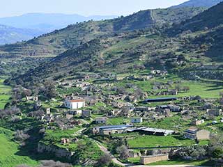
Abandoned Villages - Souskiou
It's time to return once more to the Diarizos Valley, which lies on the border of Paphos and Limassol. Before Easter we had been exploring the abandoned villages and sleepy hamlets, and I want to show some more of the pictures we took, before the approaching summer heat makes them unrecognisable. So on this blog we shall visit Souskiou. Easy to miss as you drive up the valley, it is nevertheless one of the largest abandoned villages you will likely meet on your travels in Cyprus.
The Enclosure of Agios Neophytos
The other day we set off to find the Enclosure of Agios Neophytos. We had seen a video of it and it looked interesting. A remote monastery in a cliff? That ticks all the right boxes. However, there wasn't much to see when we found the enclosure. We had neglected to pick the key up, and our view through the gate didn't reveal much. Fortunately, the journey to and from the place was so much fun that yet again I find myself having to cherry pick the best pictures rather than pad an article out. So enjoy our journey, and with the map at the end to guide you, why not plan your own route...?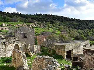
Abandoned Villages - Maronas
Last saturday my wife and I were in Paphos with a couple of hours to kill. So we decided to take a trip up the Diarizos Valley. Being on the Paphos / Limassol border, this valley is on the edge of the Paphos Life radar. However, it has a wealth of sites to visit, as you shall see over the coming weeks. Our specific destination was the abandoned village of Gerovasa. There is a fascinating bridge near to it, and we visited the village itself a few years ago, to do a geocache. However, on our way up the valley, we spotted some ramshackle buildings on the other side of the valley, and decided to take a detour...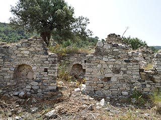
Abandoned Villages - Prastio
The Diarizos Valley really is the gift that keeps on giving. This is the fourth abandoned village we've visited recently. However, this one is a bit special, as it is an abandoned village that is truly abandoned. To get to it, you have to leave the safety of your car, and wade through shoulder-high thistles and grasses. Is it worth the journey? You decide...Related Pages

MapFasoula
Fasoula is nestled in the Diarizos Valley, between the abandoned villages of Souskiou and Maronas. We visited it in the Spring time, but have saved the blog for now, so you can remember how green Cyprus was just a few months ago, as you sit by the pool relaxing in the summer heat...
Good Pages To Visit

FB PagePaphos Life on Facebook
Like us on Facebook and stay notified of new blog posts.

FB PageOur Facebook Chat Group
Paphos Chat has been created for people who like our site and want to chat using Facebook. You can also easily upload photos of any size here. A lot of people are members of the Facebook chat group and the main forum. It's entirely up to you.

ListBlog Locations
Planning a day out? Then use our map of blog locations as a handy guide. Some of the places we visit our closer to each other than you might think, so take a look and start planning your next adventure...

eBookCyprus Road Trip 01: the Kathikas - Panagia Loop
Let me take you on a journey around the region of Paphos, Cyprus. Starting at Paphos itself, we travel to Akoursos, then Kathikas, Kritou Terra and Simou. We continue past Lasa and Kannaviou, before taking in the delights of Panagia. Getting a bit more adventurous, we visit the abandoned villages of Statos and Agios Fotios, before passing through Choulou, Letymbou and Polemi, and rejoining the main Paphos - Polis road.
The route is suitable for all types of vehicle, and requires no off-roading. The guide contains about 130 photographs including shots of all the road signs you need to pay attention to, as well as some of the highlights you may experience along the way.
There are also several maps which will help you keep your bearings.
You can do this journey in a day, or you can break it up into chunks. You can also do it in reverse, to get some completely different views. It is entirely up to you.


