Abandoned Villages: Fasli
Published 8th of November, 2020

I think we will finish the blog with some more cloud pictures. They really were spectacular today.


The Map

We have included a map, so you can see exactly where Fasli is. The road running from bottom to top is the main road from Ineia to Androlikou. As mentioned previously, our 2nd road trip follows this very route, so check it out.
Special Bonus!
We couldn't let such a nice day pass without taking some 360 shots of the area, so you can retrace the route we took in the blog in this 360 virtual tour. Remember to click the full screen icon for the best experience, and enjoy the scenery!
Page 5 of 5
If you like our blogs and the rest of our content, please consider slinging us a few euros to help us produce more content. Use the
Coffee link below if you feel so inclined. Payments are taken on a secure gateway, with no contact!❤


Related Blogs:
Pano Arodes
Pano Arodes is one of the gateways to the Akamas. It is a charming village between Kathikas and Droushia. We will be featuring it in our next eBook, so recently visited it to do some research. Naturally enough, we took lots of pictures while we were there...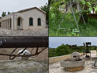
Kato Arodes
Kato Arodes is the sister village to Pano Arodes, which we recently visited. The main difference is that Kato Arodes was Turkish Cypriot before the troubles began. However, while there are signs of abandonment in places, the village certainly isn't dead...
The Akamas By Car
Nothing beats exploring the Akamas by car. A decent 4x4 can take you to places you would never normally find on foot, and the aircon can be a real life-saver. Some routes into the Akamas are bumpier than others. In this blog take a relatively bump free route which would suite the more cautious amongst you.
Droushia Lowlands
Droushia is a village of many charms, and recent roadworks. There is an abandoned village nearby too, which we set out to explore for this blog. Rather typically, we got distracted along the way, so today we bring you a report on what lies in the countryside below.Related Pages

MapAbandoned Villages: Fasli
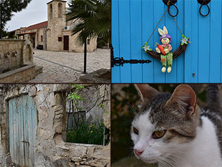
If you take the road from Ineia, on the top of the Akamas, to Androlikou, you will pass the abandoned village of Fasli. It is easy to miss, but worth the diversion if you want to do a bit of exploring. It also hosts an unusual feature we haven't found in any of the other abandoned villages we have featured over the years.
Good Pages To Visit

FB PagePaphos Life on Facebook
Like us on Facebook and stay notified of new blog posts.

FB PageOur Facebook Chat Group
Paphos Chat has been created for people who like our site and want to chat using Facebook. You can also easily upload photos of any size here. A lot of people are members of the Facebook chat group and the main forum. It's entirely up to you.

ListBlog Locations
Planning a day out? Then use our map of blog locations as a handy guide. Some of the places we visit our closer to each other than you might think, so take a look and start planning your next adventure...

eBookCyprus Road Trip 01: the Kathikas - Panagia Loop
Let me take you on a journey around the region of Paphos, Cyprus. Starting at Paphos itself, we travel to Akoursos, then Kathikas, Kritou Terra and Simou. We continue past Lasa and Kannaviou, before taking in the delights of Panagia. Getting a bit more adventurous, we visit the abandoned villages of Statos and Agios Fotios, before passing through Choulou, Letymbou and Polemi, and rejoining the main Paphos - Polis road.
The route is suitable for all types of vehicle, and requires no off-roading. The guide contains about 130 photographs including shots of all the road signs you need to pay attention to, as well as some of the highlights you may experience along the way.
There are also several maps which will help you keep your bearings.
You can do this journey in a day, or you can break it up into chunks. You can also do it in reverse, to get some completely different views. It is entirely up to you.


