Yeronisos Island
Yeronisos Island lies on the South Western corner of Cyprus, just off the Peyia Coast. From Agios Georgios you can get a glimpse of its charms, but to appreciate it fully it is best viewed from above. So let's launch the drone and go and have a closer look at this mysterious, historial location.
There She Blows

There are a number of landmarks in Paphos which can be used to help get your bearings. The Wind Farm is one, the water tower above Sunny Polemi is another. And who could possibly fail to have noticed the new tower that is being built in Paphos? When I am exploring the Akamas, Yeronisos Island always serves to remind me in which way civilisation lies.
I have gazed longingly at it many times, wondering what lay on the plateau, above its rocky cliffs. So I eventually decided to take my drone for a spin, to see what lurked there.

Flat Top

Incidentally, before we go any further, I should clear up something about the spelling. According to Google Maps, it is spelled "Yeronissos", yet the website I found with information, and indeed, Wikipedia, both spell it "Yeronisos". I used the Google spelling for the video title, so I will cover my losses and spell it without the double s here.
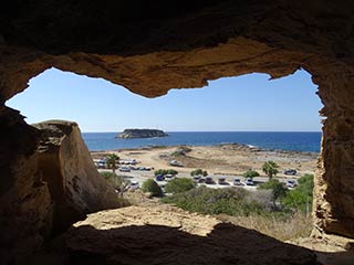
Disappearing Ruins

You can see from this picture that some of the ruins are falling foul of the ravages of nature. Bits of this are falling into the sea. But what exactly are we looking at? Let's turn to the island's dedicated website.
Close-Up

The place name Yeronisos, or “Holy Island,” is a very ancient one, known already in the first century B.C. to the Roman writer Pliny (Natural Histories 5.129-131) who speaks of an island called “Hiera” near Paphos in western Cyprus. A century later, Strabo (Geographies 14.6.4) mentions a place called “Hierocepis” nearby Paphos and Akamas. Steep cliffs, strong currents, and lack of water have long discouraged visitors from landing on Yeronisos. Its inaccessibility has allowed the island to remain one of the truly virgin sites of Cyprus, with ancient levels undisturbed since Byzantine times.

I have always been led to believe that people are not allowed on the island unless part of an Authorised Archaeological Party. However, in researching for this article, I have found nothing so far that corroborates that belief. So I can only assume the thing stopping people from visiting is its inhospitable coastline.
If you do manage to get to shore though, rest assured that the authorities are very keen on protecting historical assets, and if you are caught with an old piece of pottery in you back pocket you will be dealt with severely.
Anyway I shall continue the narrative from the website below.
The American consul Luigi Palma di Cesnola, who cleared so many Cypriot sites of their antiquities during the 19th century, claimed to have visited the Roman tombs at Agios Georgios-tis-Peyias in 1876. Apparently, he was not tempted over to Yeronisos. D.G. Hogarth carefully explored the area in 1888 and later questioned whether Cesnola had ever actually visited Cape Drepanum, so different were his findings from those described by the American consul. Hogarth did not cross over to what he calls “St. George Island” but was informed by the Commissioner, Captain Thompson, that that the island contained cisterns, just like those found opposite on the mainland.
Page 1 of 4

Related Blogs:
Cape Drepanum
It's time for another guest blog from Max. This time, he's been to the edge of the Akamas, to have a look at some of the caves at Cape Drepanum. Over to you, Max...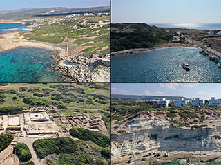
Agios Georgios From Above
Agios Georgios is a charming village that sits on the South West corner of Paphos next to the Akamas Peninsula. As well as a lovely harbour there are also some interesting caves in the cliffs, a lovely tavern and an Archaeological Site. In this article I fly our drone over the area to bring you a fresh perspective.Related Pages

MapYeronisos Island
Yeronisos Island lies on the South Western corner of Cyprus, just off the Peyia Coast. From Agios Georgios you can get a glimpse of its charms, but to appreciate it fully it is best viewed from above. So let's launch the drone and go and have a closer look at this mysterious, historial location.
Good Pages To Visit

FB PagePaphos Life on Facebook
Like us on Facebook and stay notified of new blog posts.

FB PageOur Facebook Chat Group
Paphos Chat has been created for people who like our site and want to chat using Facebook. You can also easily upload photos of any size here. A lot of people are members of the Facebook chat group and the main forum. It's entirely up to you.

ListBlog Locations
Planning a day out? Then use our map of blog locations as a handy guide. Some of the places we visit our closer to each other than you might think, so take a look and start planning your next adventure...

eBookCyprus Road Trip 01: the Kathikas - Panagia Loop
Let me take you on a journey around the region of Paphos, Cyprus. Starting at Paphos itself, we travel to Akoursos, then Kathikas, Kritou Terra and Simou. We continue past Lasa and Kannaviou, before taking in the delights of Panagia. Getting a bit more adventurous, we visit the abandoned villages of Statos and Agios Fotios, before passing through Choulou, Letymbou and Polemi, and rejoining the main Paphos - Polis road.
The route is suitable for all types of vehicle, and requires no off-roading. The guide contains about 130 photographs including shots of all the road signs you need to pay attention to, as well as some of the highlights you may experience along the way.
There are also several maps which will help you keep your bearings.
You can do this journey in a day, or you can break it up into chunks. You can also do it in reverse, to get some completely different views. It is entirely up to you.


