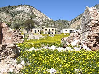
Foinikas In Bloom
Foinikas - The Nata Way

We waited a few days for the weather to improve, before setting off again. This time, we would try driving there from the Nata end. The easiest way to do that is to drive down from Nata to this bridge, and turn right immediately before it. Follow the road until you come to a building which I think belongs to the Water Department. Drive past that and take an immediate left towards the river. There is a track that runs parallel to the river, and you need to drive along that. If you don't turn left, but continue on what looks like the main track, you will find that it soon ends. It used to be the route, but it got washed away in previous high waters a couple of years ago.
River Crossing

You have to drive across the river, but there is a route of sorts. Don't be afraid of checking it out on foot first though. Obviously, you make the drive at your own risk. If you are unsure, just park your car before the water and hike.
Happy Heron

While I drove, Alex tried to snap as much of the local fauna as she could. This article is a mixture of my pictures and drone shots, and Alex's close-ups. Given that I've posted quite a few articles on Foinikas already, I will mainly use Alex's pictures in this article, as she has taken some lovely shots.
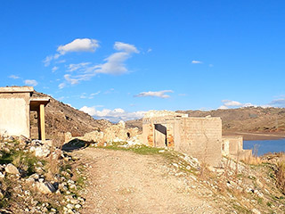
Old Friend

It is always nice to return here. It is slowly crumbling away but hasn't lost any of its charm.
High Waters

And the high waters always make the place look particularly swanky. Hard to believe that a few years ago the water level was so low that you could walk across the valley from here.
Page 2 of 10


Related Blogs:
Abandoned Villages - Foinikas
Foinikas has a special place in our family's hearts. It was the first abandoned village we explored in Cyprus, some ten years ago. We have returned to it each time we visited Cyprus, and consquently have more pictures than we could ever possibly want of the village and surrounding area. We posted some of them on our blog about the Asprokremmos Reservoir. We wanted some up-to-date photos for the Abandoned Village blog series. So last saturday we revisited Foinikas, and couldn't believe what we found when we got there...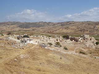
Foinikas Revisited
When we first blogged about Foinikas it was springtime, and the abandoned village was bathed in a sea of yellow. It was always an essential destination on our holidays, but we had never been in Spring, so it came as a pleasant surprise. However, it made it difficult to explore, as you never know what you might tread on when you have to wade through thigh-high flowers. As frequently happens with our blogs, people posted more information about the site in the comments. So we decided to pay another visit a few days ago, and explore it in more depth...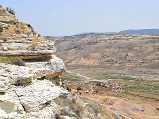
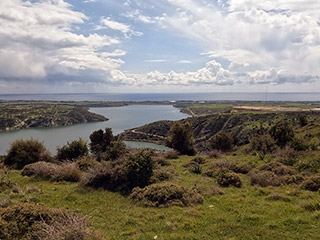
Foinikas Heights
We love Foinikas, the abandoned village on the banks of the Asprokremmos Reservoir. We've already blogged about it twice though, so we thought we would take a look at some of the surrounding countryside, and see what else the valley has to offer. Hopefully we will show you that you can find stunning, remote scenery only a stones-throw from Paphos. You don't need to travel all the way to the Akamas or Troodos to lose yourself in rugged beauty...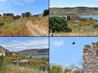
Foinikas by the Lake
The abandoned village of Foinikas lies on the banks of the Asprokremmos Reservoir. Now that the waters are lapping at the village boundaries, we thought we would pay it another visit, to see how it looks now.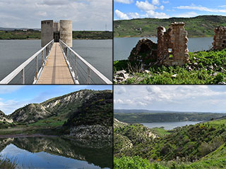
Foinikas Is Cut Off!
While Paphos waits for the Asprokremmos Dam to overflow, we thought we might as well photograph the rest of the reservoir, which is to all intents and purposes, now full. So we set off to Foinikas looking for some beautiful landscape nature shots. We didn't get very far though...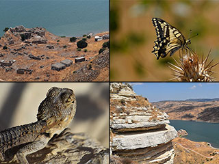
Foinikas Views
We just can't keep away from Foinikas. Somebody posted some pics of the abandoned village on our Paphos Chat facebook group, and people were asking how to get there. We bumped an old blog showing the route, but decided that a film was also needed. While we were out shooting it, we decided to take some more shots, but this time we went for some outstanding views...Related Pages

MapFoinikas In Bloom
Foinikas is an abandoned village steeped in history, that lies on the banks of the Asprokremmos Reservoir, just to the East of Paphos. Current water levels make a visit a bit tricky, but if you perservere you will be rewarded by a sea of colour as the spring flowers bring the village to life.
Video ClipFrom Foinikas Heights To Nata
You won't find Foinikas Heights in any tour guide, but it is name I gave to the hillside to the West of Foinikas, on the Asprokremmos Reservoir. It is once of the nicest, most peaceful places I know in Cyprus.
Video ClipFrom Foinikas To Nata
In our last film we drove to Foinikas. Now, we continue our journey, first through the abandoned village, and then on up the Xeros Valley to Nata.

Video ClipDriving Off Road Through Foinikas
A quick clip of a drive through the abandoned village of Foinikas near Paphos, in the spring of 2018. The area is about to become a sea of yellow.
Video ClipDon't Go This Way!
This is a short clip attempting a track that I used last year but that had been eroded in the winter rain.

360 PanoramaFoinikas in Summer
A brief look at Foinikas on a late, summer afternoon. Abandoned in 1974, the village has a history dating back to the time of the Knights Templar.
Good Pages To Visit

FB PagePaphos Life on Facebook
Like us on Facebook and stay notified of new blog posts.

FB PageOur Facebook Chat Group
Paphos Chat has been created for people who like our site and want to chat using Facebook. You can also easily upload photos of any size here. A lot of people are members of the Facebook chat group and the main forum. It's entirely up to you.

ListBlog Locations
Planning a day out? Then use our map of blog locations as a handy guide. Some of the places we visit our closer to each other than you might think, so take a look and start planning your next adventure...

eBookCyprus Road Trip 01: the Kathikas - Panagia Loop
Let me take you on a journey around the region of Paphos, Cyprus. Starting at Paphos itself, we travel to Akoursos, then Kathikas, Kritou Terra and Simou. We continue past Lasa and Kannaviou, before taking in the delights of Panagia. Getting a bit more adventurous, we visit the abandoned villages of Statos and Agios Fotios, before passing through Choulou, Letymbou and Polemi, and rejoining the main Paphos - Polis road.
The route is suitable for all types of vehicle, and requires no off-roading. The guide contains about 130 photographs including shots of all the road signs you need to pay attention to, as well as some of the highlights you may experience along the way.
There are also several maps which will help you keep your bearings.
You can do this journey in a day, or you can break it up into chunks. You can also do it in reverse, to get some completely different views. It is entirely up to you.


