The Xeros River In Winter
Protection

According to the nearby sign, there were plans to build a shelter for the church, so it obviously has some sort of historical significance. I love the old seat next to the sign. You see these all over the place. I think goat herders use them when they want a break.


The church now has a shrine in it, which isn't unusual.
Lit Flames

St George obviously features heavily. You can see from the glass receptacle in the centre that some candles are lit. So the shrine at least is still in use.
Special Rocks

Now this is interesting. A couple of the rocks in the wall are different. I actually recognise them too. They look exactly the same as that strange vein of rock we found over in Faleia. That is a couple of valleys across though. Does the vein continue this far, or did somebody hoof them across?
Donkey Farm

Down there you can see the Argonaftis Donkey Farm, and above it the village of Kelokedara.
Page 4 of 10

Related Blogs:
Should We Be Worried About Our Water?
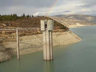
Over the last few years, the water level in the Asprokremmos has gotten lower and lower. Should we be alarmed? Has it been this low before?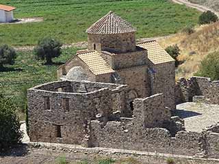
Sinti Monastery
It's time for another guest blog, and this time Max has taken a break from his minerals to show us somewhere a bit more spiritual. Over to you Max... Sinti Monastery is a very important ancient monument and not far away from Paphos, in the beautiful Xeros River Valley. I thought I would take a round trip. In order that people can visit the place all year round (even after a good Winter's rain) in a normal car I took the longer route over the hills where the roads nowadays are all properly surfaced. On the way back you can either take the same road (Winter) or use the short cut along the Xeros river bed which is only 8 km until the next village Nata.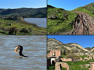
Who is Vandalising Foinikas?
The Asprokremmos is filling up fast, so we decided to see if we could still drive to Foinikas, the abandoned historical village which lies on its banks. We succeeded, and took some lovely photographs, but also had a nasty surprise...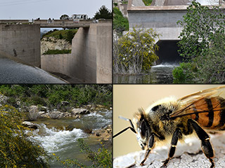
The Xeros River Flows!
The River Xeros flows into the Asprokremmos Reservoir, and when that is full, it flows right out again. So where does it go once it leaves? We decided to find out...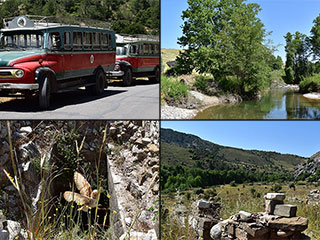
Xeros River Ruins
It looks like the sun is here to stay now, and Cyprus is quickly turning brown. The Asprokremmos is no longer overflowing, and soon, the rivers will no doubt start to run dry again. Before that happens we decided to go for a drive up Xeros Valley, and explore some ruins by the river. If you fancy a paddle, don't wait too long...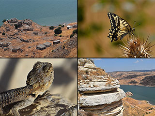
Foinikas Views
We just can't keep away from Foinikas. Somebody posted some pics of the abandoned village on our Paphos Chat facebook group, and people were asking how to get there. We bumped an old blog showing the route, but decided that a film was also needed. While we were out shooting it, we decided to take some more shots, but this time we went for some outstanding views...Related Pages

MapThe Xeros River in Winter
The Asprokremmos Reservoir is beginning to fill up! At the last count, it was close to 40% full. But where is all the water coming from? The Xeros River is normally close to dry, but now it has become a raging torrent. So let's take a look...
Good Pages To Visit

FB PagePaphos Life on Facebook
Like us on Facebook and stay notified of new blog posts.

FB PageOur Facebook Chat Group
Paphos Chat has been created for people who like our site and want to chat using Facebook. You can also easily upload photos of any size here. A lot of people are members of the Facebook chat group and the main forum. It's entirely up to you.

ListBlog Locations
Planning a day out? Then use our map of blog locations as a handy guide. Some of the places we visit our closer to each other than you might think, so take a look and start planning your next adventure...

eBookCyprus Road Trip 01: the Kathikas - Panagia Loop
Let me take you on a journey around the region of Paphos, Cyprus. Starting at Paphos itself, we travel to Akoursos, then Kathikas, Kritou Terra and Simou. We continue past Lasa and Kannaviou, before taking in the delights of Panagia. Getting a bit more adventurous, we visit the abandoned villages of Statos and Agios Fotios, before passing through Choulou, Letymbou and Polemi, and rejoining the main Paphos - Polis road.
The route is suitable for all types of vehicle, and requires no off-roading. The guide contains about 130 photographs including shots of all the road signs you need to pay attention to, as well as some of the highlights you may experience along the way.
There are also several maps which will help you keep your bearings.
You can do this journey in a day, or you can break it up into chunks. You can also do it in reverse, to get some completely different views. It is entirely up to you.


