Lapithiou
Lapithiou is a village with a doubly troubled past. Rebuilt after the 1953 Earthquake, the prefabricated replacement was then abandoned during the later troubles. But life goes on, as we shall see...
Distant Lapithiou

This is Lapithiou from a distance. If you drive into Kannaviou from the Polemi direction, there is a turning just after the first restaurant you come to on the right. It is easy to miss, so drive slowly. You can also find it by following our First Cyprus Road Trip, which takes you through Kannaviou and up to Panagia.
The mosque you will see pictures of in the next pages is behind trees on the right of the picture. The older ruins are to the right of this picture. To the left of the picture is the main road.

Old Lapithiou

We shall begin our visit in the old part. You can just make out a ruin in the centre of the picture. We are on the track that goes from Kannaviou to Statos. If you like a bit of off-roading it is a fun route. It is easy to miss the old village though, as it is shielded from the track by a ridge.
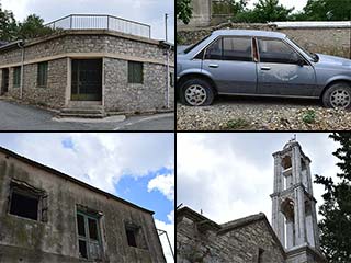
Typical Ruins

So let's get a bit of the history, from the PRIO database.
Lapithiou is a village located on the southwest foothills of the Troodos mountain range, two kilometers southwest of Panayia Khrysorroyiatissa monastery. The village was completely destroyed during the 1953 earthquake, and in 1954 the government (British) rebuilt the whole village from prefabricated houses. Goodwin claims that the village was named after a place in Greece from which its first settlers may have migrated sometime during the late Bronze Age. However, Turkish Cypriot villagers claim that the name means “small Lapithos,” and they believe that the first settlers of the village came from the town of Lapithos/Lapta in the Kyrenia region. Turkish Cypriots adopted the alternative name of Bozalan in 1958. It might have been inspired by a name in Turkey.
Old Old Lapithiou

So, prior to 1953, there was a village here with over 100 residents.
Towards The Newer Town

It is worth noting that on the hill at the top right of this picture are some more ruins, but they have been bulldozed.
Page 1 of 5

Related Blogs:
Abandoned Villages - Statos
Statos is unusual, as abandoned villages go. People deserted it not because of inter-communal fighting, but because of the threat of landslides. And then, no sooner had they emptied, some of the abandoned buildings were repopulated. Were villagers returning, or had outsiders moved in, prepared to take the risk of landslide?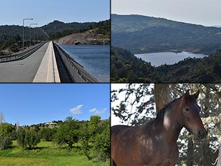
Kannaviou Countryside
You could be forgiven for thinking that the Ezousa Valley runs from the sea to Episkopi Village. But it continues through Letymbou all the way up to Kannaviou. And guess what? It's just as lovely up there.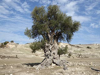
Is this the Oldest Olive Tree in Cyprus?
We were out exploring in the Akamas the other day, and we came across this lovely old Olive Tree. I can't help wondering how long it has stood here...
Is this the Oldest Olive Tree in Cyprus?
We were out exploring in the Akamas the other day, and we came across this lovely old Olive Tree. I can't help wondering how long it has stood here...Related Pages

MapLapithiou
Lapithiou is a village with a doubly troubled past. Rebuilt after the 1953 Earthquake, the prefabricated replacement was then abandoned during the later troubles. But life goes on, as we shall see...
Good Pages To Visit

FB PagePaphos Life on Facebook
Like us on Facebook and stay notified of new blog posts.

FB PageOur Facebook Chat Group
Paphos Chat has been created for people who like our site and want to chat using Facebook. You can also easily upload photos of any size here. A lot of people are members of the Facebook chat group and the main forum. It's entirely up to you.

ListBlog Locations
Planning a day out? Then use our map of blog locations as a handy guide. Some of the places we visit our closer to each other than you might think, so take a look and start planning your next adventure...

eBookCyprus Road Trip 01: the Kathikas - Panagia Loop
Let me take you on a journey around the region of Paphos, Cyprus. Starting at Paphos itself, we travel to Akoursos, then Kathikas, Kritou Terra and Simou. We continue past Lasa and Kannaviou, before taking in the delights of Panagia. Getting a bit more adventurous, we visit the abandoned villages of Statos and Agios Fotios, before passing through Choulou, Letymbou and Polemi, and rejoining the main Paphos - Polis road.
The route is suitable for all types of vehicle, and requires no off-roading. The guide contains about 130 photographs including shots of all the road signs you need to pay attention to, as well as some of the highlights you may experience along the way.
There are also several maps which will help you keep your bearings.
You can do this journey in a day, or you can break it up into chunks. You can also do it in reverse, to get some completely different views. It is entirely up to you.


