Ezousa Washout
Spring Flowers

Yellow is the predominant colour in the springtime displays in and around the Ezousa Valley.

The Road Continues

Where was I? Yes, the road ended at the river when we first visited. Now though, it has been extended and carves a route across the valley to Kallepia and Letymbou. This in itself isn't that odd. What I find confusing though, is that the road looks old. It looks like it has always been there. Yet I can distinctly remember trying to drive down the river and having to give up. We can also remember having to drive from the other direction and having great fun negotiating the riverbed.
Expanding Waters

You can see here how the waters have been cutting into the banks. The ground to the right in this picture is also incredibly muddy. Guess where we have to go?
Safely Through

That wasn't too bad. Fortunately, there were no hidden boulders, and my car has decent off-roading tyres. It was very slippery though. You have to be very careful driving off-road around here. There is one track in particular, that winds up the hill towards Axylou. From a distance, it looks well used and in good condition. Looks are deceptive. It looks well used because the ground is very chalky. But that is misleading. Years of rain have carved gorges down the road and it is impossible to drive up all the way. However, if you try, you also find it impossible to turn around, so you have to reverse backwards, down the atrocious track. Once, when we had accidently started driving down the track from above, we tried escaping back the way we came, but the chalky floor is like ice, and impossible to drive on, so we had to continue downwards. Unfortunately, I had been able to turn the car round, so this just meant I had to reverse down the hill. Alex was with me, and got out of the car to guide me round the biggest obstacles. I remember being on two wheels at times, which in a Pajero comes as quite a surprise. The killer though, was when Alex leant into the car to retrieve her phone, saying that if I went over the edge she would need to phone for help.
As I said, treat the hill tracks around here with respect...
No Through Road

Anyway, I had driven through all the mud, then successfully navigated an area of the track that had been overtaken by the river. However, it became clear that a lot of the track was now underwater. I learned a few weeks ago that roads like this can get very deep, when I was approaching Foinikas from Nata. So I got out of the car to check the route.
Then things got strange!
Page 4 of 5

Related Blogs:
From Episkopi To Kallepia
As part of Pafos 2017, there is a tour of Episkopi Village and the surrounding countryside planned for this saturday 18th February.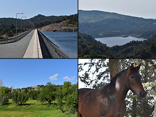
Kannaviou Countryside
You could be forgiven for thinking that the Ezousa Valley runs from the sea to Episkopi Village. But it continues through Letymbou all the way up to Kannaviou. And guess what? It's just as lovely up there.Related Pages

MapEzousa Washout
On our numerous visits to the dam over the last few days, we have also taken the opportunity to explore the countryside between the Asprokremmos and Polemi. How had the rains affected the Ezousa Valley? Was one of our hidden picnic areas still intact? Could I even get from Ezousa to Kallepia, like I had done on a previous blog? Would I rescue some German tourists? The short answers are badly, ish, no and yes. For a more in-depth discussion, read on.
Good Pages To Visit

FB PagePaphos Life on Facebook
Like us on Facebook and stay notified of new blog posts.

FB PageOur Facebook Chat Group
Paphos Chat has been created for people who like our site and want to chat using Facebook. You can also easily upload photos of any size here. A lot of people are members of the Facebook chat group and the main forum. It's entirely up to you.

ListBlog Locations
Planning a day out? Then use our map of blog locations as a handy guide. Some of the places we visit our closer to each other than you might think, so take a look and start planning your next adventure...

eBookCyprus Road Trip 01: the Kathikas - Panagia Loop
Let me take you on a journey around the region of Paphos, Cyprus. Starting at Paphos itself, we travel to Akoursos, then Kathikas, Kritou Terra and Simou. We continue past Lasa and Kannaviou, before taking in the delights of Panagia. Getting a bit more adventurous, we visit the abandoned villages of Statos and Agios Fotios, before passing through Choulou, Letymbou and Polemi, and rejoining the main Paphos - Polis road.
The route is suitable for all types of vehicle, and requires no off-roading. The guide contains about 130 photographs including shots of all the road signs you need to pay attention to, as well as some of the highlights you may experience along the way.
There are also several maps which will help you keep your bearings.
You can do this journey in a day, or you can break it up into chunks. You can also do it in reverse, to get some completely different views. It is entirely up to you.


