Ezousa Estuary
A couple of years ago we stumbled across a sad little memorial at the mouth of the Ezousa River. We thought we would check it out again a few days ago, to see what the area looked like after the rains. The question was, how would we get to it? In the past, the Ezousa was always dry at this point. Now it was in full flow...
From Geroskipou

To get to the mouth of the Ezousa, the easiest route used to be from the municipal beach at Geroskipou; just keep on driving when you got to the end of the road. Ok, a 4x4 was required, but it was easily doable. However, when we tried this approach this time around, we were soon thwarted.

Back To Geroskipou

So we turned round and headed back to the beach. From there we drove up to the old Airport Road (B6) and headed towards Timi. We took the bridge across the Ezousa River and immediately after, we took the turning right.
Road Out!

We have been on this route before, but this time there was a problem here too. Some brave soul had driven to the left of the collapsed road, but we wanted a more stable route.
The River

Towards The Sea

Fortunately, there are several routes to the sea along the river bank. We took a higher one, which helped us get closer. This is probably the ugliest part of Ezousa Valley. Unfortunately, it is used as a dumping ground by people. I can only presume a lot of the rubbish has been washed out to sea.
Page 1 of 4

Related Blogs:
Happy Easter
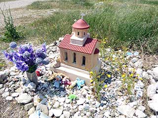
We were out doing our Annual Easter Egg Hunt this morning. It took us down through the Esouza Valley, and finally to the sea. I won't be doing a blog article on the final part of this journey, as it isn't in the same league as the two sections I have previously blogged about. However, we did stumble across this shrine. At first glance, I took it as a typical shrine you see fairly frequently in Cyprus. However, a second glance revealed it to be rather unusual.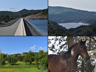
Kannaviou Countryside
You could be forgiven for thinking that the Ezousa Valley runs from the sea to Episkopi Village. But it continues through Letymbou all the way up to Kannaviou. And guess what? It's just as lovely up there.Related Pages

MapEzousa Estuary
A couple of years ago we stumbled across a sad little memorial at the mouth of the Ezousa River. We thought we would check it out again a few days ago, to see what the area looked like after the rains. The question was, how would we get to it?
Good Pages To Visit

FB PagePaphos Life on Facebook
Like us on Facebook and stay notified of new blog posts.

FB PageOur Facebook Chat Group
Paphos Chat has been created for people who like our site and want to chat using Facebook. You can also easily upload photos of any size here. A lot of people are members of the Facebook chat group and the main forum. It's entirely up to you.

ListBlog Locations
Planning a day out? Then use our map of blog locations as a handy guide. Some of the places we visit our closer to each other than you might think, so take a look and start planning your next adventure...

eBookCyprus Road Trip 01: the Kathikas - Panagia Loop
Let me take you on a journey around the region of Paphos, Cyprus. Starting at Paphos itself, we travel to Akoursos, then Kathikas, Kritou Terra and Simou. We continue past Lasa and Kannaviou, before taking in the delights of Panagia. Getting a bit more adventurous, we visit the abandoned villages of Statos and Agios Fotios, before passing through Choulou, Letymbou and Polemi, and rejoining the main Paphos - Polis road.
The route is suitable for all types of vehicle, and requires no off-roading. The guide contains about 130 photographs including shots of all the road signs you need to pay attention to, as well as some of the highlights you may experience along the way.
There are also several maps which will help you keep your bearings.
You can do this journey in a day, or you can break it up into chunks. You can also do it in reverse, to get some completely different views. It is entirely up to you.


