Yeronisos Island

In Janury 1989, Joan Breton Connelly and Doris Miller of New York University visited Agios Georgios-tis-Peyias, followed by a trip atop Yeronisos in the summer of 1989 by Joan Connelly, Stuart and Laina Swiny, and Dimitris Michaelides in the boat of Mr. Andreas Stavrou of Peyia.
On June 15 1990, Order 223/1989 declared Yeronisos to be an ancient monument, adding it to the First Schedule of the Antiquities Law, as published in the Gazette.

Dig Remnants

Just think, in years to come Archaeologists will be picking through Archaeological Dig Sites left by current-day Archaeologists. And if you think that sounds far-fetched, you will find evidence of Byzantine Archaeologists all over the place, if you pay attention to the signs you see on museum visits.
Also in June, 1990, New York University was awarded a license to explore and excavate Yeronisos Island and its surrounding waters under the direction of Prof. Joan Breton Connelly. To date, one archaeological survey season (1990), two ecological survey seasons (1990, 1992), eleven excavation seasons (1992-1994, 1996-1997, 2004-2006, 2009-11) and seven study seasons (1995, 2000-2003, 2007-2008) have been completed.
Current Archaeology

It should be noted that the Yeronisos website has not been updated since 2012. The digs continue to this day, as you can be seen by the presence of this green protective covering.
In June of 1990, President John Brademas of New York University and his wife, Dr. Mary Ellen Brademas, visited Yeronisos and Agios Georgios-tis-Peyias by Cypriot Police Helicopter, inaugurating the opening of the University’s excavations at the site.
During the 1990 season, Peter P. Blanchard I11 of the Nature Conservancy of Mt. Desert Island, Maine and the Trust for Public Land, New York City undertook surveys of the Yeronisos flora and avian fauna. He collected, recorded and photographed plant samples and prepared an ecological map of Yeronisos. Geographical and general contour maps were obtained from the Geological Survey Department and the Department of Land Surveys which prepared a new aerial contour map of Yeronisos at 1:250, courtesy of Mr. Loucas Telemachou.
Work In Progress

In 1992, the Cyprus Land Survey Office of Pafos renewed the benchmark on Yeronisos, setting a brass plate in a concrete column at the highest point on the island. This marks the precise elevation of 21.65m above sea level. The benchmark was determined off of a Level 6 Geodetic Survey point set on the mainland acropolis at Agios Georgios in 1923.
Mapped Out

During the 1992 season, architect Andrew Wixom, aided by G.H.R. Wright, undertook a survey of the island with an electronic distance meter and prepared a new state plan of structures exposed prior to the start of the New York University Excavations. Wixom and Wright set three datum points (iron reinforcement rods in cement cased in PCV tubing) along a true North-South, East-West grid of 5 X 5 meter squares. This grid stretches over the entire site and extends across the channel to the mainland, allowing future underwater survey teams to utilize the same grid as the land operation.
Page 3 of 4

Related Blogs:
Cape Drepanum
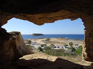
It's time for another guest blog from Max. This time, he's been to the edge of the Akamas, to have a look at some of the caves at Cape Drepanum. Over to you, Max...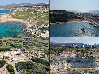
Agios Georgios From Above
Agios Georgios is a charming village that sits on the South West corner of Paphos next to the Akamas Peninsula. As well as a lovely harbour there are also some interesting caves in the cliffs, a lovely tavern and an Archaeological Site. In this article I fly our drone over the area to bring you a fresh perspective.Related Pages

MapYeronisos Island
Yeronisos Island lies on the South Western corner of Cyprus, just off the Peyia Coast. From Agios Georgios you can get a glimpse of its charms, but to appreciate it fully it is best viewed from above. So let's launch the drone and go and have a closer look at this mysterious, historial location.
Good Pages To Visit

FB PagePaphos Life on Facebook
Like us on Facebook and stay notified of new blog posts.

FB PageOur Facebook Chat Group
Paphos Chat has been created for people who like our site and want to chat using Facebook. You can also easily upload photos of any size here. A lot of people are members of the Facebook chat group and the main forum. It's entirely up to you.

ListBlog Locations
Planning a day out? Then use our map of blog locations as a handy guide. Some of the places we visit our closer to each other than you might think, so take a look and start planning your next adventure...

eBookCyprus Road Trip 01: the Kathikas - Panagia Loop
Let me take you on a journey around the region of Paphos, Cyprus. Starting at Paphos itself, we travel to Akoursos, then Kathikas, Kritou Terra and Simou. We continue past Lasa and Kannaviou, before taking in the delights of Panagia. Getting a bit more adventurous, we visit the abandoned villages of Statos and Agios Fotios, before passing through Choulou, Letymbou and Polemi, and rejoining the main Paphos - Polis road.
The route is suitable for all types of vehicle, and requires no off-roading. The guide contains about 130 photographs including shots of all the road signs you need to pay attention to, as well as some of the highlights you may experience along the way.
There are also several maps which will help you keep your bearings.
You can do this journey in a day, or you can break it up into chunks. You can also do it in reverse, to get some completely different views. It is entirely up to you.


