Routhouni Bridge
Bumpy Ride

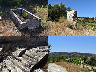
The road eventually becomes a track, but don't despair. We are nearly there now.
Pay Attention!

Now, when you get here, you need to pay attention. The bridge is on your left, but it is shrouded in trees.
From Above

This is an aerial shot, courtesy of our drone. You can also see a large pipe. You are more likely to spot this than the bridge itself.
Routhouni Bridge

And here is the bridge itself. It was built to link the villages of Amargeti and Eledio. The Frankian Period ran from 1192 to 1489, so it's looking good for its age.
Routhouni Bridge gets its name from the region it resides in. This is what the internet tells us:
First, going back a few years, the bridge got its name from the area that has the same name, thanks to two natural holes that are located in a rock and whenever it rained and the water passed from there. The older people of the region say that "the nostrils run".
The Nostrils

We've blogged about this area in the past. You can see links to them below the main article. In one of the articles we included the above picture. It sounds like the two natural holes mentioned above. We shall have to return in the next rainy season, to see if we can see the nostrils run.
Page 3 of 8

Related Blogs:
Old Axylou
We first went looking for the old village of Axylou two years ago. We didn't find it, though we had a lot of fun in the process. The other day, after a chance tip-off, we had another go...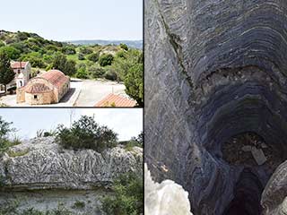
The Eledio Quartz Mines
While researching for new places to visit, we stumbled across references to a Quartz Mine in Eledio, a village not far from Polemi. This sort of thing is right up our alley, so we packed our camera and set off in the trusty Pajero...Related Pages

MapRouthouni Bridge
We've shown you a number of Venetian Bridges over the years, but today we're going a bit further back in time. Routhouni Bridge is a Frankian Bridge, which is even older. It can be found in the countryside near to the village of Amargeti. Let's go and take a look.
Good Pages To Visit

FB PagePaphos Life on Facebook
Like us on Facebook and stay notified of new blog posts.

FB PageOur Facebook Chat Group
Paphos Chat has been created for people who like our site and want to chat using Facebook. You can also easily upload photos of any size here. A lot of people are members of the Facebook chat group and the main forum. It's entirely up to you.

ListBlog Locations
Planning a day out? Then use our map of blog locations as a handy guide. Some of the places we visit our closer to each other than you might think, so take a look and start planning your next adventure...

eBookCyprus Road Trip 01: the Kathikas - Panagia Loop
Let me take you on a journey around the region of Paphos, Cyprus. Starting at Paphos itself, we travel to Akoursos, then Kathikas, Kritou Terra and Simou. We continue past Lasa and Kannaviou, before taking in the delights of Panagia. Getting a bit more adventurous, we visit the abandoned villages of Statos and Agios Fotios, before passing through Choulou, Letymbou and Polemi, and rejoining the main Paphos - Polis road.
The route is suitable for all types of vehicle, and requires no off-roading. The guide contains about 130 photographs including shots of all the road signs you need to pay attention to, as well as some of the highlights you may experience along the way.
There are also several maps which will help you keep your bearings.
You can do this journey in a day, or you can break it up into chunks. You can also do it in reverse, to get some completely different views. It is entirely up to you.


