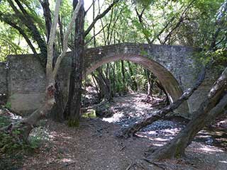
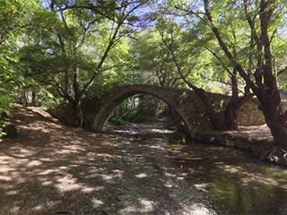
Kelefos Bridge
Bridge Full Frontal

Before we explore, let's just grab a couple more pictures of the bridge from the front. It really is lovely.

To The Signpost

Once you cross the bridge you can't help but notice this sign. This tells you about the "Venetian Bridges" Nature Trail. It runs from beyond Elia Bridge (which we shall cover in another blog), past Kelefos Bridge, to the picnice site at Pera Vasa, then west to Roudia Bridge, and ending at Vretsia. I am sure it is a very picturesque route, though I know at least one portion is closed. However, as it is a linear route, you would either have to walk all the way back again (some 27km), or have pre-arranged a lift home from Vretsia.
Up The Garden Path

However, we can do a small portion of the trail, just to see what we can see. So follow that arrow.
Keep To The Track

The track does split a few times, but it seems to rejoin itself as you progress up the slope.
Page 4 of 8


Related Blogs:
Roudia Bridge
Now that we have covered the route from Vretsia to Kelefos, let's return to the subject of Venetian Bridges. This time, we will feature Roudia Bridge. For years this eluded us, as we drove past it without realising it was there. With the help of the previous blog, you should now be able to locate it and know where to park the car. So let's take a look at the bridge itself...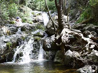
Chantara Falls
This waterfall, tucked in the woods behind the mountain village of Foini, has long been a favourite of ours. You can either pay it a quick visit, and have a paddle in the lower falls, or, if you are a bit more adventurous, you can climb the steps to the upper falls, and take a dip. The really adventurous can go beyond that, and have a stream-hopping adventure through the ancient woodland...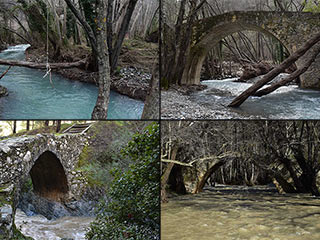
The Camel Trail Venetian Bridges
Over the last few days we've been trying to visit the three most popular Venetian Bridges on the Camel Trail, to see how they have coped with all the rain. It took a while to get to Roudia, but now finally, we can show you what we found.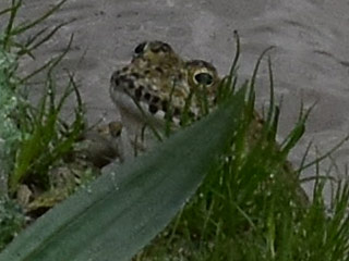
Archimandrita Surprise
Why is Freddy the Frog smiling? He's just visited one of Archimandrita's hidden jewels, and hasn't all the winter rain brought it up a treat?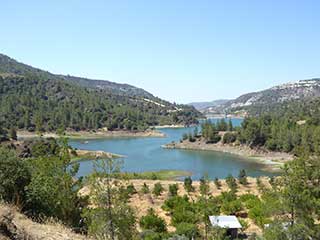
From Vretsia to Kelefos
This is another Road-Trip blog. Paphos Forest contains many treasures, and two of it's finest are the Venetian Bridges Roudia and Kelefos. Of the two, the latter is easy to locate. However, Roudia eluded us for some time, as it is easy to miss, being buried in woodland. So we have put together this guide, showing the route we took from our starting point of the abandoned village of Vretsia, through the forest to Kelefos and beyond. The aim of this blog is not to provide a de-facto route through the forest. After all, tracks get closed, and new tracks get opened every year. No, we mainly want to show you what you can expect to find should you decide to venture into the forest. We will do other blogs on the bridges themselves; today is all about the journey...Related Pages

MapKelefos Bridge
Kelefos Bridge is probably the most well-known of all the Venetian Bridges in Cyprus, for good reasons. It features on the UK TV holiday adverts for Cyprus, showing a couple cycling over it on an afternoon ride. In reality, you won't find any cyclists here, but you will find a bridge full of charm, and surrounding countryside to match...
360 PanoramaKelefos Bridge
Kelefos Bridge is probably the most well-known of all the Venetian Bridges in Cyprus, for good reasons. It even features on the UK TV holiday adverts for Cyprus, showing a couple cycling over it on an afternoon ride. In reality, you won't find any cyclists here, but you will find a bridge full of charm, and surrounding countryside to match...
Good Pages To Visit

FB PagePaphos Life on Facebook
Like us on Facebook and stay notified of new blog posts.

FB PageOur Facebook Chat Group
Paphos Chat has been created for people who like our site and want to chat using Facebook. You can also easily upload photos of any size here. A lot of people are members of the Facebook chat group and the main forum. It's entirely up to you.

ListBlog Locations
Planning a day out? Then use our map of blog locations as a handy guide. Some of the places we visit our closer to each other than you might think, so take a look and start planning your next adventure...

eBookCyprus Road Trip 01: the Kathikas - Panagia Loop
Let me take you on a journey around the region of Paphos, Cyprus. Starting at Paphos itself, we travel to Akoursos, then Kathikas, Kritou Terra and Simou. We continue past Lasa and Kannaviou, before taking in the delights of Panagia. Getting a bit more adventurous, we visit the abandoned villages of Statos and Agios Fotios, before passing through Choulou, Letymbou and Polemi, and rejoining the main Paphos - Polis road.
The route is suitable for all types of vehicle, and requires no off-roading. The guide contains about 130 photographs including shots of all the road signs you need to pay attention to, as well as some of the highlights you may experience along the way.
There are also several maps which will help you keep your bearings.
You can do this journey in a day, or you can break it up into chunks. You can also do it in reverse, to get some completely different views. It is entirely up to you.


