Aphrodite's Bridge
While I was assembling the map for a recent driving film I published between Pissouri and Kouklia, I noticed that there was a new marker for a "hidden medieval bridge", just in front of Aphrodite's Hills Resort. Well, red rag to a bull and all that, so I paid the area a visit, to see what I could find...
The Map

This is how the bridge is represented on Google Maps. I was puzzled as I have driven along the road many times and not seen anything. However, if it was visible from the road it wouldn't be called hidden, would it?

Satellite View

This was the view from Bing. The bridge is just visible from above. If you look via Google Street View the bridge is completely covered.
Time Travel

If you jump back in time 60 years, you will see that the bridge was actually in use, as part of the old road. The bridge is towards the bottom right of the picture.
Present Day

I was therefore in for a bit of a surprise when I arrived at the scene. The bridge is anything but hidden, and is instead prominently on display.
Drone View

It certainly looks a bit different from the satellite photos! At first glance you might think the area had been cleared just for the sake of the bridge, but as you shall see, it looks like they have been clearing out the whole riverbed.
Page 1 of 3

Related Blogs:
Aphrodite's Rock
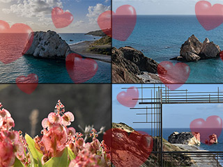
Valentine's Day is upon us once again, so let's forget about all our troubles and take a romantic trip to Petra to Romiou, or Aphrodite's Rock, as we tend to call it. Today we present a triple whammy of photographic fun, from myself, my lovely wife, and our fully licensed drone. So snuggle up with your loved one and enjoy the beauty that is one of the many jewels in Cyprus' romantic crown.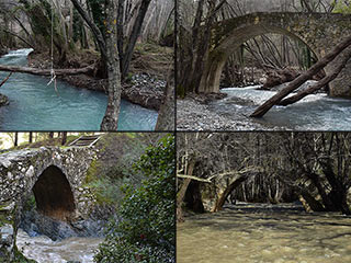
The Camel Trail Venetian Bridges
Over the last few days we've been trying to visit the three most popular Venetian Bridges on the Camel Trail, to see how they have coped with all the rain. It took a while to get to Roudia, but now finally, we can show you what we found.Related Pages

MapAphrodite's Bridge
While I was assembling the map for a recent driving film I published between Pissouri and Kouklia, I noticed that there was a new marker for a "hidden medieval bridge", just in front of Aphrodite's Hills Resort. Well, red rag to a bull and all that, so I paid the area a visit, to see what I could find...
Good Pages To Visit

FB PagePaphos Life on Facebook
Like us on Facebook and stay notified of new blog posts.

FB PageOur Facebook Chat Group
Paphos Chat has been created for people who like our site and want to chat using Facebook. You can also easily upload photos of any size here. A lot of people are members of the Facebook chat group and the main forum. It's entirely up to you.

ListBlog Locations
Planning a day out? Then use our map of blog locations as a handy guide. Some of the places we visit our closer to each other than you might think, so take a look and start planning your next adventure...

eBookCyprus Road Trip 01: the Kathikas - Panagia Loop
Let me take you on a journey around the region of Paphos, Cyprus. Starting at Paphos itself, we travel to Akoursos, then Kathikas, Kritou Terra and Simou. We continue past Lasa and Kannaviou, before taking in the delights of Panagia. Getting a bit more adventurous, we visit the abandoned villages of Statos and Agios Fotios, before passing through Choulou, Letymbou and Polemi, and rejoining the main Paphos - Polis road.
The route is suitable for all types of vehicle, and requires no off-roading. The guide contains about 130 photographs including shots of all the road signs you need to pay attention to, as well as some of the highlights you may experience along the way.
There are also several maps which will help you keep your bearings.
You can do this journey in a day, or you can break it up into chunks. You can also do it in reverse, to get some completely different views. It is entirely up to you.


