The Asprokremmos Reservoir Is Filling Up!
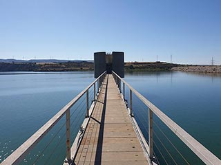
Asprokremmos Reflections

There was a bit of a breeze blowing but I managed to get a nice reflection shot.

More Rain On Its Way

As you can see from this shot, we have not yet had our fill of rain, so the likelihood of the dam overflowing is pretty high. Especially when you consider how much snow there is in the mountains at the moment. The Asprokremmos Reservoir is fed by the Xeros River, which begins up in Paphos Forest. If you saw our recent Paphos Snow blog, you will know that the forest itself got a dusting of the white powder. That will eventually find its way here. On the way it will pass beneath Roudia Bridge, which is a lovely place and somewhere I really need to get back to.
Also in this shot you can just make out Foinikas in the distance. It is now pretty much inaccessible by road. There is a dodgy track to the left of the water plant, but you then have to go across a very muddy ford and up some very muddy slopes. I plan on visiting it on foot in a few weeks though. In spring it turns a beautiful golden yellow, thanks to the wild flowers. I visited last year but was a few days too late, and the weather was very overcast. The pictures weren't very pleasing, so I want to get there on a sunny day, to appreciate it fully. That will be a bit of a hike though, especially with my assortment of cameras.
Coming Soon...

Is it worth a visit if it overflows? It is worth a visit whether it overflows or not. It is a lovely place, with beautiful views, and you can get some nice snacks at the moment. So what's not to like? And if you get to see it overflow, then lucky you.
A Note On Parking

This is the little parking bay, next to the concession stands. If you are visiting just after it overflows, I would park further down hill and walk up. It can get very crowded here and you could well get blocked in. To give yourself a real chance of escaping easily, turn the car round as well, so you are facing downhill.
The Last Overflow
I shall leave you with the film we recorded the last time it overflowed. Hopefully we will be making another one soon!
Page 4 of 4


Related Blogs:
Asprokremmos Dam is Looking Good!
I popped down to Koloni Green Point this morning, as I had a mountain of hedge clippings to dispose of. As I was in the area I thought I would take a quick drive up to the dam to see how it was fairing...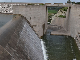
Asprokremmos Dam Revisited
The Asprokremmos Dam first started to overflow over a week ago. We filmed it at the time, but vowed to return once it had got into full swing...
The Xeros River in Winter
The Asprokremmos Reservoir is beginning to fill up! At the last count, it was close to 40% full. But where is all the water coming from? The Xeros River is normally close to dry, but now it has become a raging torrent. So let's take a look...
The Xeros River Flows!
The River Xeros flows into the Asprokremmos Reservoir, and when that is full, it flows right out again. So where does it go once it leaves? We decided to find out...Related Pages

MapThe Asprokremmos Reservoir Is Filling Up!
For a time the overflow of the Asprokremmos appeared to be a Septennial event, but thanks to a very wet January it looks like it might be overflowing ahead of schedule. The other day I went to the dam to assess the chances of witnessing another watery spectacle...

Video ClipAsprokremmos Dam Overflows
Here is our clip of the Asprokremmos Dam overflowing in 2019

Video ClipAwesome Asprokremmos!
What a difference a couple of days make. We return to Asprokremmos and after the recent rains it now looks astounding!
Good Pages To Visit

FB PagePaphos Life on Facebook
Like us on Facebook and stay notified of new blog posts.

FB PageOur Facebook Chat Group
Paphos Chat has been created for people who like our site and want to chat using Facebook. You can also easily upload photos of any size here. A lot of people are members of the Facebook chat group and the main forum. It's entirely up to you.

ListBlog Locations
Planning a day out? Then use our map of blog locations as a handy guide. Some of the places we visit our closer to each other than you might think, so take a look and start planning your next adventure...

eBookCyprus Road Trip 01: the Kathikas - Panagia Loop
Let me take you on a journey around the region of Paphos, Cyprus. Starting at Paphos itself, we travel to Akoursos, then Kathikas, Kritou Terra and Simou. We continue past Lasa and Kannaviou, before taking in the delights of Panagia. Getting a bit more adventurous, we visit the abandoned villages of Statos and Agios Fotios, before passing through Choulou, Letymbou and Polemi, and rejoining the main Paphos - Polis road.
The route is suitable for all types of vehicle, and requires no off-roading. The guide contains about 130 photographs including shots of all the road signs you need to pay attention to, as well as some of the highlights you may experience along the way.
There are also several maps which will help you keep your bearings.
You can do this journey in a day, or you can break it up into chunks. You can also do it in reverse, to get some completely different views. It is entirely up to you.


